- 800 g Balloon purchased from scientificsales.com


Balloon Launch
- 217 ft^3 of Helium
- Parachute from 2011 launches
- Cosmic ray detection experiment (ISO 3200 B&W film)
- Communication Pod
- APRS
- Vernier
- Inside temperature
- Outside temperature
- Outside pressure
- Outside humidity
- Stability Pod
- Camera Pod (attached to stability pod)

Flight[]
The flight lasted approximately 3 hours 3 minutes. The path can be viewed on aprs.fi.
Launch[]

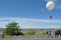
Launch Site
The balloon was launched from McNary Beach near Hermiston, OR. It was launched at 3:00pm local time. Once the balloon was filled with the helium we made sure all the lines were untangled. On our first attempt to launch the balloon we noticed that the weight of the equipment was too much. Due to insufficient lift, the launch crew all agreed that the Vernier equipment was less important and the easiest to remove.
Burst[]
The highest recorded altitude was 95,623ft. This was recorded at 5:34pm local time between Waitsburg and Dayton. Throughout the flight each position packet (sent every 30 seconds) was reliably sent to APRS-IS. The packet sent directly after the highest altitude was not received. We think this is due to the tumbling the pod experiences in free fall causing the polarization of the antenna to fluctuate widely. The chase team noticed the lack of the packet and correctly thought that the balloon had burst before the next packet with a lower altitude was received.
Landing[]
The balloon landed on a ridge line near North Patit Road east of Dayton at about 6:03pm local time. The last APRS packet sent to the Internet was at 6:02:30pm at 4,114ft (approximately 800 ft above the ground where the balloon landed).
Shortly after landing, at 6:06pm local time, SPOT sent a position. We were fairly sure this was the location where the balloon had landed. 10 minutes later that was confirmed when SPOT sent another identical position report. SPOT continued to send positions until the balloon was recovered.
Recovery[]


The recovery time programed the position of the balloon into a handheld GPS and walked right towards the balloon. The recovery team had a VX-8R handheld radio with them to listen for APRS packets from the balloon. They confirmed that the balloon was still sending valid position packets once they had arrived at the balloon but did not see how far away those packets were received (to see how close the searchers would have to get if SPOT had not transmitted a position on the ground).
Pictures[]
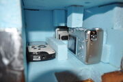
There were three cameras sent up in this balloon launch. A Kodak Zx3 video camera pointed down taking 720p video. A Canon PowerShot A530 pointed straight out the side of the pod configured to take pictures every 12 seconds. And a GoPro action camera also pointed out the side taking 1080p video.

Camera Setup
Kodak Zx3[]
The Kodak Zx3 was pointed straight down and set to take video. Unfortunately it only recorded about two minutes of video on the ground while the balloon was still being prepped for launch. We think that a button was pushed down by some of the foam supporting the camera which stopped the recording. In future we should check that all buttons are free of being pressed by their supports.
Canon PowerShot A530[]
An older model Canon PowerShot A530 was configured with custom CHDK firmware to take a picture every 12 seconds. 1448 pictures over 4 hours 50 minutes were taken only using 1.3GB of the 2GB SD card. That included about 27 minutes before launch and 1 hour 20 minutes after landing.
Download Pictures (zipped jpg 1.3GB)
")
")
")
")
")
")
")
")
")
")
")
")
GoPro[]
The GoPro video camera was configured to take 1080p video. The video looked good until several thousand feet where condensation began to form on the lens. The remaining video looked very bad and could only be used to get an indication as to what was happening outside. We think that some anti-condensation spray could be used to fix the problem. It could also be used to see how long the gyroscope lasted by listening to the sound of the motor. The 16GB SD card filled up after about 2 hours 24 minutes. This included 1 hour 55 minutes of flight time, up to about 70,000ft.
")
")
")
")
")
")
")
")
")
Gyroscope[]
Watching the video it was hard to tell if the gyroscope had any affect on the stability of the video. By listening to the video from the GoPro we determined the gyroscope lasted for 56 minutes. At that point we believe the battery was depleted. After the flight we measured the voltage of the battery to be 700mV and attaching a fresh battery to the gyroscope made it start spinning. The belt was worn but not broken.
Tracking[]
Two forms of tracking were used on this launch. A Byonics MicroTrak RTG FA was the primary tracking unit. A SPOT Satellite Messenger was used as a backup recovery unit.
MicroTrak[]
The Byonics MicroTrak was purchased in the MicroTrak high altitude package. This included the transmitter, antenna, and high altitude GPS. The tracker was configured to send position every 30 seconds time slotted at the GPS minute. This way we would know exactly when to expect packets.
The MicroTrak is an APRS tracker on the national APRS frequency of 144.390MHz. The tracker was configured with the digipath Wide2-1. This would allow digipeaters to digipeat each packet once. At the launch site all packets above 1000ft AGL were received directly by an IGate station. At the landing site all packets above 7000ft AGL were received directly by an IGate station. During the entire 3 hour flight every packet was being digipeated by an digipeater. This resulted in unnecessary APRS traffic. This may or may not be a concern.